
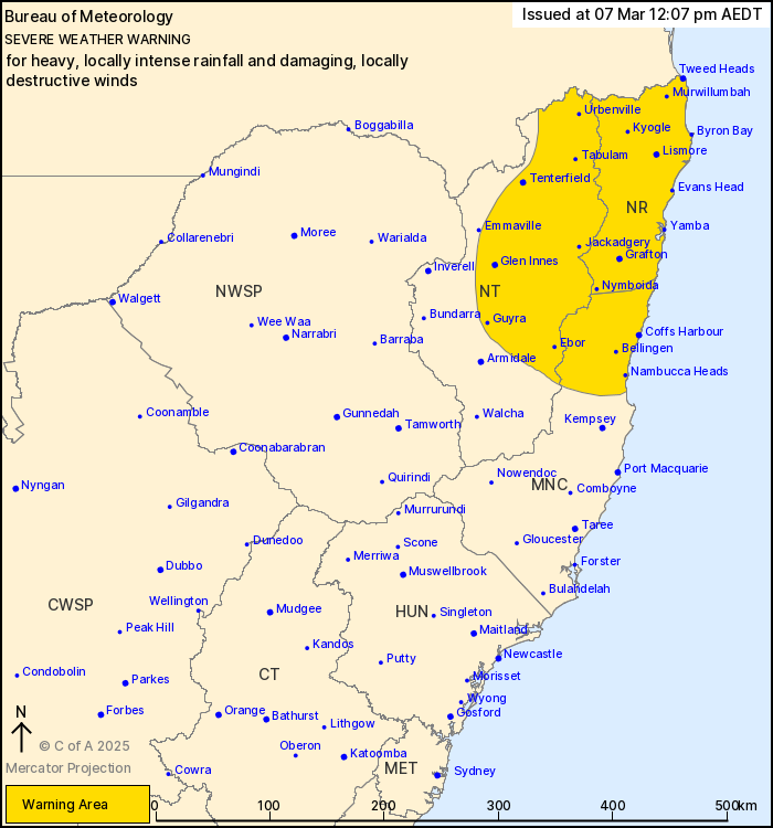
Source: Bureau of Meteorology
For people in Northern Rivers and parts of Mid North Coast and
Northern Tablelands Forecast Districts.
Issued at 12:07 pm Friday, 7 March 2025.
HEAVY TO LOCALLY INTENSE RAINFALL AND DAMAGING TO DESTRUCTIVE
WINDS EXPECTED OVER THE NORTHEAST.
Weather Situation: Tropical Cyclone Alfred continues to move
slowly to the west this morning, it is expected to make landfall
along the southeast Queensland coast early Saturday morning before
moving inland during the weekend. Heavy rainfall and damaging winds
will extend well to the south of the centre of the system over
parts of the Northern Rivers, Northern Tablelands and Mid North
Coast.
HEAVY RAINFALL which may lead to FLASH FLOODING is developing
about parts of the Mid North Coast and Northern Rivers and is
expected to become more widespread through the warning area east of
Tenterfield from this afternoon and into Saturday. Six-hourly
rainfall totals between 70 and 130 mm are likely, increasing to
around 200 mm about the Border Ranges. 24-hourly rainfall totals
between 150 and 250 mm are likely, increasing to between 300 and
350 mm about the Border Ranges.
In the same areas, locally INTENSE RAINFALL which may lead to
DANGEROUS AND LIFE-THREATENING FLASH FLOODING may develop from this
afternoon and continue into Saturday. Six-hourly rainfall totals
between 200 and 250 mm and 24-hour totals between 350 and 450 mm
are possible, particularly over the Northern Rivers and the eastern
facing slopes of the Northern Tablelands. All rainfall numbers are
dependent on the movement and position of the system.
DAMAGING WINDS averaging 60 to 65 km/h with peak gusts to 120 km/h
are occurring over the coastal fringe of northeastern New South
Wales north of Yamba, and about the Border Ranges, and may extend
to as far south as Grafton later today. DAMAGING WINDS with peak
gusts of 100 km/h are also possible across parts of the Northern
Tablelands, extending more broadly throughout the warning area
during Friday and Saturday with showers and thunderstorms.
DESTRUCTIVE WIND GUSTS up to 155 km/h associated with Tropical
Cyclone Alfred may develop over parts of the Northern Rivers as far
south as Cape Byron from tonight into Saturday morning. DESTRUCTIVE
WIND GUSTS are also possible with showers and thunderstorms over
the coastal fringe from this afternoon and during Saturday.
A Tropical Cyclone Advice and Forecast Track Map is current for
Tropical Cyclone Alfred.
A Coastal Hazard Warning and Hazardous Surf Warning is
current.
A Flood Watch and Flood Warnings are current for northeast New
South Wales.
For these products, please refer to:
http://www.bom.gov.au/australia/warnings/
Locations which may be affected include Lismore, Grafton, Coffs
Harbour, Tenterfield, Yamba, Woolgoolga, Sawtell and Dorrigo.
100 km/h wind gust was recorded at Gold Coast Airport
(Coolangatta) at 1:43 am.
The State Emergency Service advises that people should:
* Move vehicles under cover or away from trees.
* Secure or put away loose items around your house, yard and
balcony.
* Keep at least 8 metres away from fallen power lines or objects
that may be energised, such as fences.
* Trees that have been damaged by fire are likely to be more
unstable and more likely to fall.
* Report fallen power lines to either Ausgrid (131 388), Endeavour
Energy (131 003), Essential Energy (132 080) or Evoenergy (131 093)
as shown on your power bill.
* Don't drive, ride or walk through flood water.
* Keep clear of creeks and storm drains.
* If you are trapped by flash flooding, seek refuge in the highest
available place and ring 000 if you need rescue.
* Be aware that run-off from rainfall in fire affected areas may
behave differently and be more rapid. It may also contain debris
such as ash, soil, trees and rocks.
* After bushfires, heavy rain and the loss of foliage can make the
ground soft and heavy, leading to a greater chance of
landslides.
* Stay vigilant and monitor conditions. Note that the landscape
may have changed following bushfires.
* For emergency help in floods and storms, ring your local SES
Unit on 132 500.
07/Mar/2025 01:18 AM


