
Source: Bureau of Meteorology
Issued at 11:54 am ACST on Tuesday 24 March 2026
Flood Watch Number: 6
MODERATE TO MAJOR FLOODING OCCURRING ACROSS PARTS OF THE TOP
END
ONGOING FLOOD IMPACTS LIKELY TO CONTINUE ACROSS THE FLOOD WATCH
AREA FOR THE NEXT FEW DAYS
Moderate to heavy rainfall associated with Ex-Tropical Cyclone
Narelle was observed across large parts of the Flood Watch area
over the weekend, worsening existing flooding and causing renewed
flooding in some catchments.
Further showers and thunderstorms are forecast over the next two
days, however widespread significant rainfall is not
expected.
River and creek levels are rising, with elevated water levels
occurring across much of the Top End. Roads closures are in place,
with some communities isolated. Check road conditions before
travelling. Flood impacts are likely to continue across the Flood
Watch area for much of this week.
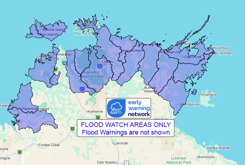
Catchments likely to be affected include:
Fitzmaurice River
Moyle River
Finniss River
Tiwi Islands
Upper Adelaide River
Mary River
Wildman River
South Alligator River
East Alligator River
Goomadeer River
Liverpool River
Blyth River
Goyder River
Buckingham River
Koolatong River
Walker River
Flood Warnings are current for the following catchment(s):
Katherine, Daly above Douglas, Lower Daly, Lower Adelaide,
Waterhouse and Roper
For the latest flood and weather warnings see
www.bom.gov.au/weather-and-climate/warnings-and-alerts
For the latest rainfall and river level information see
www.bom.gov.au/australia/flood
Safety Advice:
Don't drive, walk, swim or play in floodwater because it is
dangerous.
Stay away from flooded drains, rivers, streams and
waterways.
Obey road closure signs. Plan ahead so you don't drive on flooded
roads.
Check the ABC and local media for updates. The situation can
change quickly, so stay informed.
For local emergency management warnings and advice visit
www.securent.nt.gov.au.
For emergency assistance call SES on telephone number 132 500. In
life-threatening emergencies, call 000 (triple zero)
immediately.
Rainfall and River
Conditions Map
24/Mar/2026 02:40 AM

