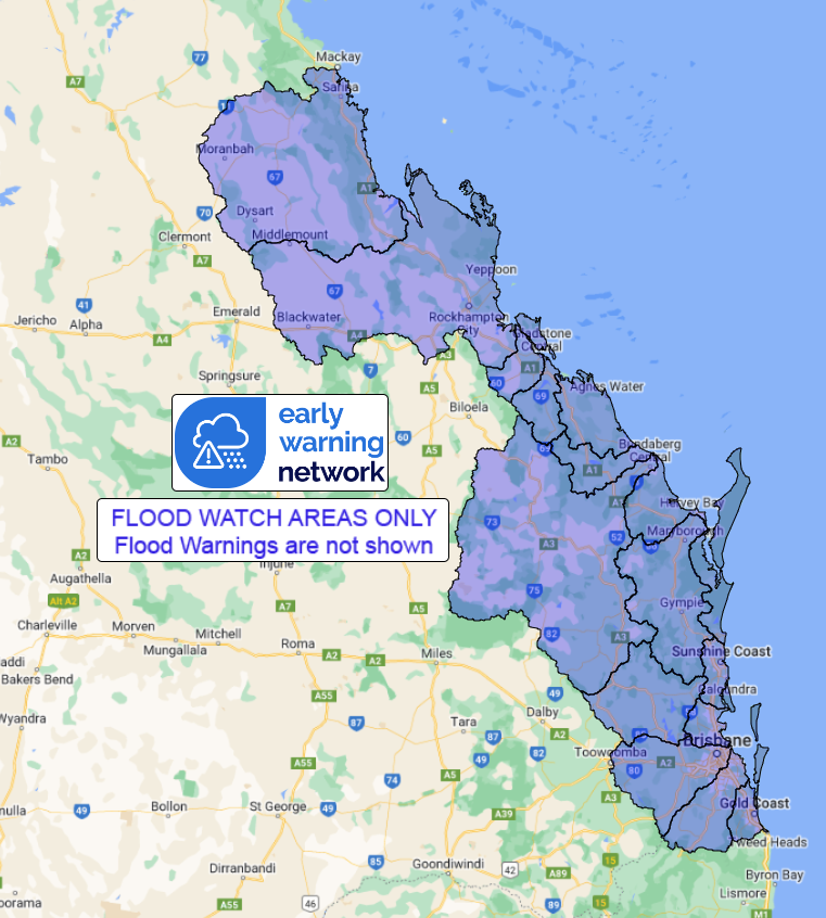
Source: Bureau of Meteorology
Flood Watch for Coastal Catchments from Sarina to Tweed
Heads
Issued at 12:20 pm EST on Monday 12 August 2024
Flood Watch Number: 4
ISOLATED MINOR TO MODERATE FLOODING POSSIBLE ACROSS PARTS OF THE
FLOOD WATCH AREA FROM LATE TUESDAY
A rain band extends over eastern and central Queensland. An upper
trough extends over Queensland enhancing showers and thunderstorms.
The upper trough will move south down the east coast from today,
moving offshore late on Wednesday. A surface trough is forecast to
develop near the central Queensland coast from today, most likely
between Carmila and Hervey Bay, and will enhance rainfall, winds,
and seas in its vicinity. The coastal trough will weaken from
Thursday.
Catchments within the Flood Watch Area are moderately dry but
beginning to wet up after rainfall in coastal areas over the last
few days.
Moderate to locally heavy rainfall is possible over the Flood
Watch Area from the remainder of Monday until Wednesday, easing on
Thursday.
Significant uncertainty still remains in the timing and location
of the rainfall, although the coast and adjacent ranges are most
likely to see the heaviest falls.
Localised river level rises and flash flooding are likely within
the areas of heaviest rainfall, with isolated minor to moderate
riverine flooding possible.
Due to the localised nature of the heavier falls, at this stage it
is not possible to be more specific about the areas of highest
flood risk.
Flooding may result in disruption to transport routes and
isolation of some communities.
Catchments likely to be affected include:
Connors, Isaac and Styx Rivers and Plane Creek
Mackenzie and Fitzroy Rivers and Shoalwater and Water Park
Creeks(Riverine flooding not expected in Fitzroy or Mackenzie
Rivers at this stage)
Calliope River
Boyne River
Baffle Creek
Kolan River
Burnett River
Burrum and Cherwell Rivers
Mary River
Noosa River
Sunshine Coast Rivers and Creeks
Pine and Caboolture Rivers
Upper Brisbane River
Lower Brisbane River(including the Bremer River and Lockyer,
Laidley and Warrill Creeks, excluding the lower Brisbane River
itself)
Logan and Albert Rivers
Gold Coast Rivers and Creeks
See www.bom.gov.au/qld/warnings to view the current flood, weather
and cyclone products for Queensland.
For more information on the Flood Watch Service:
http://www.bom.gov.au/water/floods/floodWarningServices.shtml
Flood Safety Advice:
This Flood Watch means that people living or working along rivers
and creeks should monitor the latest weather forecasts and
warnings.
Remember: If it's flooded, forget it.
For flood emergency assistance contact the SES on 132 500.
For life threatening emergencies, call Triple Zero (000)
immediately.
Current emergency information is available at
www.qld.gov.au/alerts.
This advice is also available by dialling 1300 659 219 at a low
call cost of 27.5 cents, more from mobile, public and satellite
phones.
Warning, rainfall and river information are available at
www.bom.gov.au/qld/flood/
Rainfall and River
Conditions Map

12/Aug/2024 02:43 AM


