
Source: Bureau of Meteorology
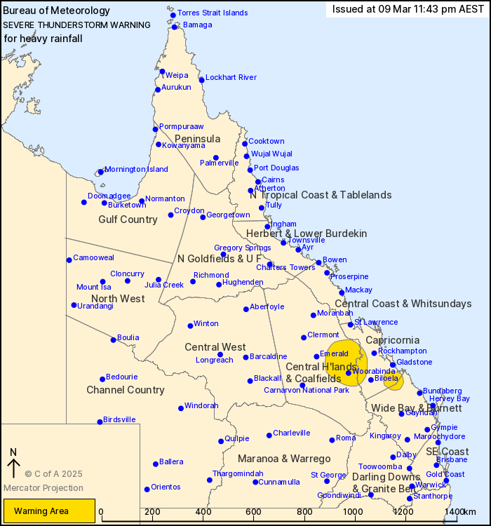
For people in parts of Central Highlands and Coalfields,
Capricornia and Wide Bay and Burnett Forecast Districts.
Issued at 11:43 pm Sunday, 9 March 2025.
Severe thunderstorms continuing over the central east this
evening.
Weather Situation: Slow-moving storms in an extremely moist
atmosphere are continuing to produce heavy rainfall across parts of
the Capricornia and Central Highlands and Coalfields.
Severe thunderstorms are likely to produce heavy rainfall that may
lead to flash flooding in the warning area over the next several
hours. Locations which may be affected include Blackwater,
Baralaba, Woorabinda, Duaringa, Comet and Miriam Vale.
Severe thunderstorms are no longer occurring in the Central Coast
and Whitsundays and Maranoa and Warrego districts and the warning
for these districts is CANCELLED.
A separate Severe Weather Warning for heavy rainfall, locally
intense rainfall remains current over Southeast Coast and parts of
Wide Bay and Burnett and Darling Downs and Granite Belt Forecast
Districts. Please refer to http://www.bom.gov.au/warnings/
Significant observations:
111 km/h wind gust was recorded at Thargomindah at 5:07 pm.
105 mm WAS RECORDED AT FRED HAIGH HIGHWAY IN THE 1 HOUR TO 2:41
PM.
108 mm was recorded at Hermans Gully (Bucca Rd) in the 2 hours to
1:35 pm.
72 mm was recorded at Bucca Weir Highway in the 1 hour to 1:32
pm.
Emergency services advise people to:
* Park your car undercover away from trees.
* Close doors and windows.
* Keep asthma medications close by. Storms and wind can trigger
asthma attacks.
* Charge mobile phones and power banks in case the power goes
out.
* Put your pets somewhere safe and make sure they can be
identified in case they get lost.
* Do not drive now unless you have to because conditions are
dangerous.
* Tell friends, family and neighbours in the area.
* Go inside a strong building now. Stay inside until the storm has
passed.
09/Mar/2025 02:01 PM


