
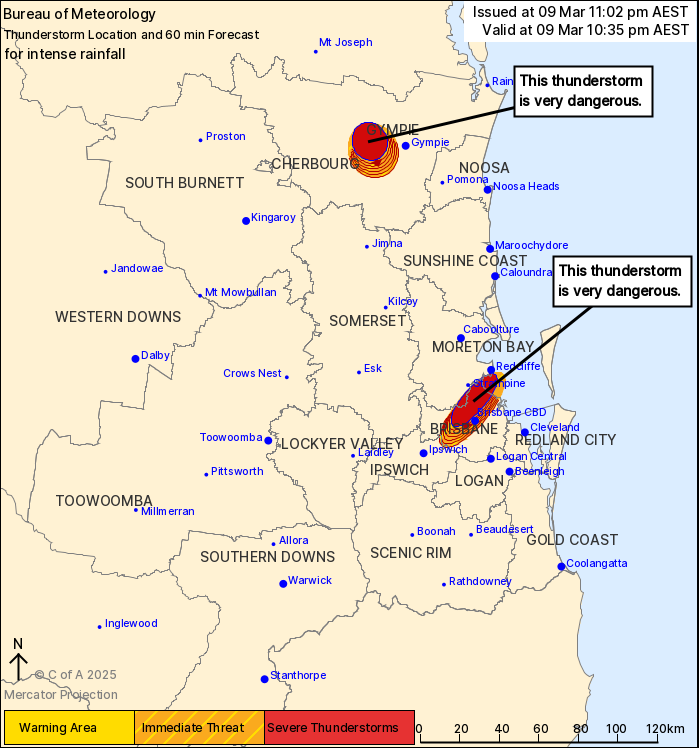
Source: Bureau of Meteorology
For people in parts of Gympie, Brisbane City, Moreton Bay and
Ipswich Council Areas.
Issued at 11:02 pm Sunday, 9 March 2025.
INTENSE RAINFALL WITH VERY DANGEROUS THUNDERSTORMS NEAR BRISBANE
AND WEST OF GYMPIE.
The Bureau of Meteorology warns that, at 11:00 pm, VERY DANGEROUS
THUNDERSTORMS likely to produce intense rainfall that may lead to
dangerous and life-threatening flash flooding were detected near
the ranges between Gympie and Murgon, Boondall, Sandgate and
Brighton. These thunderstorms are slow moving. They are forecast to
affect Brisbane CBD by 11:05 pm and the area southwest of Gympie
and Brisbane Airport by 11:35 pm.
A separate Severe Weather Warning for heavy rainfall, locally
intense rainfall remains current over Southeast Coast and parts of
Wide Bay and Burnett and Darling Downs and Granite Belt Forecast
Districts. Please refer to http://www.bom.gov.au/warnings/
147 mm WAS RECORDED AT KINGSHOLME (MONTEGO HILLS) IN THE 3 HOURS
TO 8:54 PM.
115 mm was recorded at Wongawallan (Welch Pioneer Park) in the 3
hours to 9:34 pm.
120 mm was recorded at Hotham Creek in the 3 hours to 8:59
pm.
102 mm was recorded at Carbrook in the 3 hours to 6:18 pm
Emergency services advise people to:
* If you have children make sure they are with you or an adult you
trust.
* Park your car undercover away from trees.
* Close doors and windows.
* Keep asthma medications close by. Storms and wind can trigger
asthma attacks.
* Charge mobile phones and power banks in case the power goes
out.
* Put your pets somewhere safe and make sure they can be
identified in case they get lost.
* Do not drive now unless you have to because conditions are
dangerous.
* Tell friends, family and neighbours in the area.
* Go inside a strong building now. Stay inside until the storm has
passed.
09/Mar/2025 01:11 PM


