
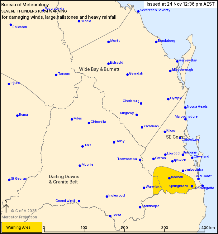
Source: Bureau of Meteorology
For people in parts of Southeast Coast and Darling Downs and
Granite Belt Forecast Districts.
Issued at 12:36 pm Monday, 24 November 2025.
Severe thunderstorms have developed in the southeast
Weather Situation: A humid and unstable airmass is in place over
the southeast of the state and a southeasterly wind change is
expected to reach the area later in the afternoon. Severe
thunderstorms have triggered about the NSW border and are expected
to continue throughout the afternoon, expanding to other parts of
the southeast and including Brisbane.
Severe thunderstorms are likely to produce damaging winds, large
hailstones and heavy rainfall that may lead to flash flooding in
the warning area over the next several hours. Locations which may
be affected include Boonah, Springbrook, Mount Tamborine and
Beaudesert.
Emergency services advise people to:
* Park your car undercover away from trees.
* Close doors and windows.
* Keep asthma medications close by. Storms and wind can trigger
asthma attacks.
* Charge mobile phones and power banks in case the power goes
out.
* Put your pets somewhere safe and make sure they can be
identified in case they get lost.
* Do not drive now unless you have to because conditions are
dangerous.
* Tell friends, family and neighbours in the area.
* Go inside a strong building now. Stay inside until the storm has
passed.
24/Nov/2025 02:44 AM

