
Source: Bureau of Meteorology
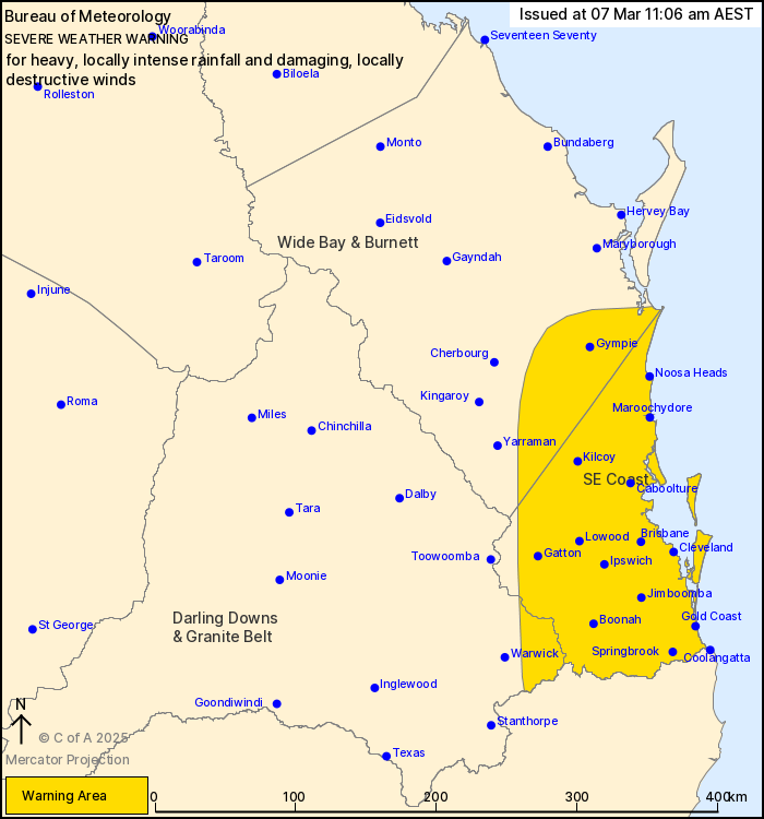
For people in Southeast Coast and parts of Wide Bay and Burnett
and Darling Downs and Granite Belt Forecast Districts.
Issued at 11:06 am Friday, 7 March 2025.
HEAVY TO LOCALLY INTENSE RAINFALL AND DAMAGING TO DESTRUCTIVE
WINDS EXPECTED OVER SOUTHEAST QUEENSLAND.
Weather Situation: Tropical Cyclone Alfred continues to move
slowly to the west this morning, it is expected to make landfall
along the southeast Queensland coast during Saturday morning before
moving inland during the weekend. Bands of heavy rainfall are
developing over the southeast coast this morning, with damaging
winds now affecting coastal and island communities.
HEAVY RAINFALL which may lead to FLASH FLOODING is developing
across the Moreton Bay islands, Gold Coast and Scenic Rim this
morning, forecast to become more widespread over central parts of
the Southeast Coast district, including Brisbane, Ipswich and
Caboolture, from late this afternoon and into Saturday. Six-hourly
rainfall totals between 70 and 130 mm are likely, increasing to
around 200 mm about the Scenic Rim and Gold Coast Hinterland.
24-hourly rainfall totals between 150 and 250 mm are likely,
increasing to around 300 to 350 mm about the Scenic Rim and Gold
Coast Hinterland.
Locally INTENSE RAINFALL which may lead to DANGEROUS AND
LIFE-THREATENING FLASH FLOODING may develop from this afternoon and
continue into Saturday near and south of the system centre, and in
bands of showers and thunderstorms wrapping around the system.
Six-hourly rainfall totals between 200 and 250 mm and 24-hourly
totals between 350 and 450 mm are possible. All rainfall numbers
are dependent on the movement and position of the system.
DAMAGING WINDS averaging 60 to 65 km/h with peak gusts to 120 km/h
to continue this morning over the island communities, and
developing through Friday over the southeast Queensland coast and
Scenic Rim. This risk will then extend more broadly across the
warning area through Friday night and into Saturday, especially
within showers and thunderstorms..
DESTRUCTIVE WIND GUSTS of up to 155 km/h associated with Tropical
Cyclone Alfred may develop about coastal, island and elevated
locations near and to the south of the system centre from Friday
evening into Saturday morning. DESTRUCTIVE WIND GUSTS are also
possible in showers and thunderstorms along the coastal fringe
through Saturday.
A Tropical Cyclone Advice and Forecast Track Map is current for
Tropical Cyclone Alfred.
A Coastal Hazard Warning and Hazardous Surf Warning is
current.
A Flood Watch and Flood Warnings are current for South East
Queensland.
For these products, see
http://www.bom.gov.au/australia/warnings/
Locations which may be affected include Gold Coast, Brisbane,
Maroochydore, Gympie, Caboolture, Coolangatta and Ipswich.
100 km/h wind gust was recorded at Gold Coast Airport
(Coolangatta) at 1:43 am.
Emergency services advise people to:
* If you have children make sure they are with you or an adult you
trust.
* Pack away, secure or tie down outdoor furniture, toys and
trampolines if it s safe to do so.
* Park your car undercover away from trees.
* Close doors and windows.
* Keep asthma medications close by. Storms and wind can trigger
asthma attacks.
* Charge mobile phones and power banks in case the power goes
out.
* Put your pets somewhere safe and make sure they can be
identified in case they get lost.
* Do not drive now unless you have to because conditions are
dangerous.
* Tell friends, family and neighbours in the area.
* Go inside a strong building now. Stay inside until the storm has
passed.
07/Mar/2025 01:12 AM


