
Source: Bureau of Meteorology
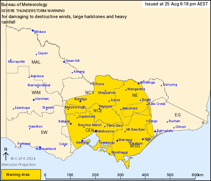
For people in Central, North Central, North East, West and South
Gippsland and parts of East Gippsland, Northern Country and South
West Forecast Districts.
Issued at 6:18 pm Sunday, 25 August 2024.
DESTRUCTIVE WINDS POSSIBLE ABOUT ELEVATED TERRAIN IN NORTHEASTERN
RANGES.
Weather Situation: a strong cold front with strong associated
upper-level winds is crossing the state. This high-instability,
high-shear environment is producing conditions conducive to severe
thunderstorm development, unusual for this time of year.
Thunderstorms will be fast moving towards the southeast and are
likely to continue throughout the afternoon and into the
evening.
Severe thunderstorms are likely to produce damaging winds, large
hailstones and heavy rainfall that may lead to flash flooding over
the next several hours in the Central, North Central, North East,
West and South Gippsland and parts of the East Gippsland, Northern
Country and South West districts. Locations which may be affected
include Bendigo, Shepparton, Seymour, Maryborough, Ballarat,
Geelong, Melbourne, Wodonga, Wangaratta and Traralgon.
VERY DANGEROUS THUNDERSTORMS are likely to produce destructive
winds, large hailstones and heavy rainfall that may lead to flash
flooding over the next several hours in parts of the North East,
East Gippsland and West and South Gippsland districts. Locations
which may be affected include Falls Creek, Mt Hotham and Mt
Buller.
3cm hail observed near Bendigo earlier this afternoon.
98 km/h wind gust was recorded at Horsham at 4:13 pm.
93 km/h wind gust was recorded at Warracknabeal Airport at 4:34
pm.
91 km/h wind gust was recorded at Ben Nevis at 4:41 pm.
98 km/h wind gust was recorded at Hopetoun Airport at 4:42
pm.
100 km/h wind gust was recorded at Mount Hotham at 4:57 pm.
104 km/h wind gust was recorded at Mount Buller at 5:22 pm.
The State Emergency Service advises that people should:
* If driving conditions are dangerous, safely pull over away from
trees, drains, low-lying areas and floodwater. Avoid travel if
possible.
* Stay safe by avoiding dangerous hazards, such as floodwater,
mud, debris, damaged roads and fallen trees.
* Be aware - heat, fire or recent storms may make trees unstable
and more likely to fall when it's windy or wet.
* Check that loose items, such as outdoor settings, umbrellas and
trampolines are safely secured. Move vehicles under cover or away
from trees.
* Stay indoors and away from windows.
* If outdoors, move to a safe place indoors. Stay away from trees,
drains, gutters, creeks and waterways.
* Stay away from fallen powerlines - always assume they are
live.
* Be aware that in fire affected areas, rainfall run-off into
waterways may contain debris such as ash, soil, trees and rocks.
Heavy rainfall may also increase the potential for landslides and
debris across roads.
* Stay informed: Monitor weather warnings, forecasts and river
levels at the Bureau of Meteorology website, and warnings through
VicEmergency website/app/hotline.
25/Aug/2024 08:24 AM


