
Source: Bureau of Meteorology
TROPICAL CYCLONE ADVICE NUMBER 2
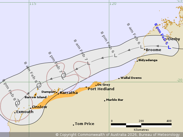
Issued at 8:33 pm WST on Thursday 5 February 2026
Headline:
Tropical Low 21U is expected to develop off the north Pilbara
coast.
Areas Affected:
Warning Zone
None.
Watch Zone
Onslow to De Grey, including Karratha, Port Hedland and Barrow
Island.
Cancelled Zone
None.
Details of Tropical Low 21U at 8:00 pm AWST:
Intensity: Tropical Low, sustained winds near the centre of 30
kilometres per hour with wind gusts to 85 kilometres per
hour.
Location: within 65 kilometres of 17.8 degrees South 123.8 degrees
East, estimated to be 165 kilometres east of Broome and 610
kilometres east northeast of Port Hedland.
Movement: west at 25 kilometres per hour.
Tropical Low 21U is located over the western Pilbara and is moving
to the west. It is expected to move offshore of the Kimberley coast
during Friday. Once offshore, 21U is expected to develop over
waters off the Pilbara coast during the weekend, reaching category
1 strength during Saturday.
Over the weekend, 21U is forecast to move in a general west
southwest direction, remaining parallel to the Pilbara coast. From
later Sunday or Monday, 21U is expected to begin weakening as it
takes a more southerly track towards the far west Pilbara coast or
northern Gascoyne coast.
Hazards:
GALES with DAMAGING WIND GUSTS to 120 km/h are possible for
coastal parts between De Grey and Onslow during Saturday and early
Sunday.
Widespread moderate to locally HEAVY RAINFALL which may lead to
FLASH FLOODING is possible from late Friday for the Pilbara
coast.
Tides between Exmouth and Wickham are likely to rise above the
normal high tide mark on Saturday and Sunday and LARGE WAVES may
produce MINOR FLOODING of low-lying coastal areas.
Recommended Action:
Ensure you know what to do in a cyclone. For the latest DFES
community alerts and warnings visit www.emergency.wa.gov.au or
download the Emergency WA app.
Current
Tropical Cyclones
05/Feb/2026 12:41 PM


