
Source: Bureau of Meteorology
Issued at 1:10 pm EDT on Friday 7 March 2025
Flood Watch Number: 6
MAJOR RIVERINE FLOODING WITH SIGNIFICANT LOCALISED FLOODING
POSSIBLE ALONG THE NORTHERN RIVERS AND MID NORTH COAST CATCHMENTS
FROM LATER FRIDAY INTO THE WEEKEND
MINOR TO ISOLATED MAJOR FLOODING POSSIBLE FROM SUNDAY INTO EARLY
NEXT WEEK FOR PARTS OF THE NORTH WEST AND CENTRAL WEST
CATCHMENTS
MINOR TO MAJOR FLOOD WARNINGS CURRENT FOR THE NORTHERN RIVERS AND
MID NORTH COAST
Rainfall associated with Tropical Cyclone Alfred is likely to
cause rapid and dangerous river rises and extensive moderate to
major flooding along the NSW Northern Rivers and Mid North Coast
from later Friday through to the weekend. Rainfall may extend
inland during Sunday into early next week and may result in minor
to major flooding in the North West and Central West Catchments
from Sunday. There is a chance that the flood watch area may expand
further over the coming days as certainty develops about the
movement of the system into the new week.
The location of the heaviest rainfall and most severe flooding
will depend on the track of Tropical Cyclone Alfred. The recent
slower movement of TC Alfred is likely to delay the onset of the
heaviest rainfall, with heavy and locally intense rainfall forecast
to increase Friday night and into the weekend over Northern NSW.
The heaviest rainfall will be south of the Tropical Cyclone
track.
Minor to major flood warnings are current for a widespread area
along the Northern Rivers and Mid North Coast.
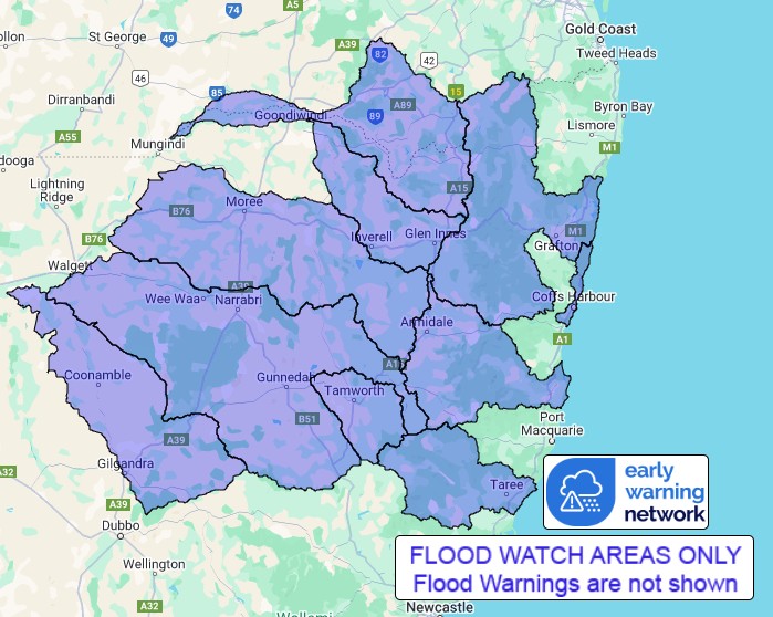
Catchments in the Northern Rivers are wet. Catchments in the North
West and Central West are relatively dry.
A Flood Watch is current in Queensland for the Macintyre
River.
Dangerous flash flooding is expected. High tides and large waves
are expected to increase the flood risk and impacts in low lying
coastal areas. Areas at risk will continue to be revised during the
coming days.
Flood Classes (minor, moderate, major) are only defined for
catchments where the Bureau provides a flood warning service.
Catchments likely to be affected include:
Clarence River
moderate to major flooding
Coffs Coast
Macleay River
moderate to major flooding
Manning and Gloucester Rivers
minor flooding
Upper Macintyre River
minor to major flooding
Gwydir River
minor to moderate flooding
Macintyre River
Peel River
minor to moderate flooding
Namoi River
minor to moderate flooding
Castlereagh River
minor flooding
Flood warnings are current for the Tweed, Brunswick, Wilsons,
Richmond, Orara, Bellinger, Kalang, Nambucca, Hastings and Camden
Haven Rivers.
For the latest flood and weather warnings see
www.bom.gov.au/nsw/warnings/
For the latest rainfall and weather forecasts see
www.bom.gov.au/australia/meteye/
For the latest rainfall and river level information see
www.bom.gov.au/nsw/flood
Flood Safety Advice:
This Flood Watch means that people living or working along rivers
and streams must monitor the latest weather forecasts and warnings
and be ready to move to higher ground should flooding
develop.
Flood Warnings will be issued if Minor Flood Level is expected to
be exceeded at key sites along the main rivers for which the Bureau
of Meteorology provides a flood warning service.
Severe Weather Warnings will be issued or updated if very heavy
rain is forecast or observed.
For more information on the Flood Watch Service:
http://www.bom.gov.au/water/floods/floodWarningServices.shtml
FloodSafe advice is available at www.ses.nsw.gov.au
For emergency assistance call the SES on telephone number 132
500
For life threatening emergencies, call 000 immediately
Rainfall and River
Conditions Map
07/Mar/2025 02:34 AM


