
Source: Bureau of Meteorology
Issued at 7:50 pm EST on Thursday 6 March 2025
Headline:
Tropical Cyclone Alfred moving towards the southeast Queensland
coast, impacts expected to increase from later this evening.
Areas Affected:
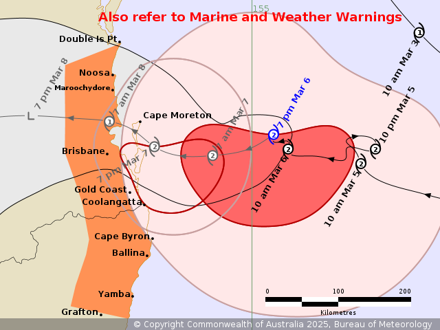
Warning Zone
Double Island Point in Queensland to Grafton in New South Wales,
including Brisbane, Gold Coast, Sunshine Coast, Byron Bay and
Ballina but not including Grafton .
Watch Zone
None.
Cancelled Zone
None.
Details of Tropical Cyclone Alfred 22U at 7:00 pm AEST [8:00 pm
AEDT]:
Intensity: Category 2, sustained winds near the centre of 95
kilometres per hour with wind gusts to 130 kilometres per
hour.
Location: within 30 kilometres of 27.2 degrees South 155.3 degrees
East, estimated to be 225 kilometres east of Brisbane and 215
kilometres east northeast of Gold Coast.
Movement: west northwest at 6 kilometres per hour.
Tropical Cyclone Alfred is slowly moving towards the southeast
Queensland coast.
Alfred is currently category 2 and is expected to remain of
similar intensity until the centre starts to interact with the
coast and islands. The centre of Alfred is expected to cross the
coast Friday night or early Saturday morning, most likely between
Noosa and Coolangatta.
Hazards:
Gales with DAMAGING WIND GUSTS to 120 kilometres per hour are
developing near the coast between Cape Moreton and Cape Byron.
Gales with DAMAGING WIND GUSTS to 120 kilometres per hour are
expected to develop along the remaining southeast Queensland and
northeastern New South Wales coastal and island communities between
Noosa and Ballina overnight Thursday into Friday morning, possible
extending as far south as Grafton and as far north as Double Island
Point. These DAMAGING WINDS are forecast to persist during Friday
before easing during late Saturday morning.
DESTRUCTIVE WIND GUSTS of up to 155 kilometres per hour may
develop about coastal and island locations near, and to the south
of, the cyclone centre, as Alfred's destructive core approaches the
coast.
A DANGEROUS STORM TIDE is likely along the coastal foreshore for
exposed areas between Cape Moreton and Yamba, including the Gold
Coast and Byron Bay beaches, ahead of the coastal crossing time on
the high tides. Tides are likely to rise significantly above the
highest high tide mark with damaging waves and dangerous inundation
of coastal low-lying areas.
ABNORMALLY HIGH TIDES are likely to continue causing MINOR
FLOODING of coastal low lying areas between Double Island Point and
Grafton, particularly during the time of high tides early Friday
morning (tonight) and early Saturday morning (Friday night).
DAMAGING SURF leading to significant beach erosion remains likely
for the open beaches between Double Island Point and Grafton, and
further south over the New South Wales coast. Separate Coastal
Hazard and Hazardous Surf warnings are current for southeast
Queensland and New South Wales coasts.
HEAVY RAINFALL is developing for southeast Queensland and
northeastern New South Wales. HEAVY to locally INTENSE RAINFALL
which may lead to DANGEROUS AND LIFE-THREATENING FLASH FLOODING may
occur near and south of the cyclone centre as Alfred approaches and
crosses the coast. Separate Severe Weather Warning and Flood
Watches are current for southeast Queensland and northeast New
South Wales.
Refer to associated warnings for Queensland and New South Wales at
http://www.bom.gov.au/australia/warnings.
Recommended Action:
People between Cape Moreton and Cape Byron, including the Morton
Bay Islands should immediately commence or continue preparations,
especially securing boats and property.
People between Cape Byron and Grafton in New South Wales, as well
as Brisbane and Double Island Point in Queensland should take
precautions and listen to the next advice.
- For cyclone preparedness and safety advice, visit the Get Ready
Queensland website (www.getready.qld.gov.au)
- If you choose to take shelter away from your home, stay COVID-19
safe and pack a mask and hand sanitiser (if you have them).
- For emergency assistance call the Queensland State Emergency
Service or New South Wales State Emergency Service (SES) on 132 500
(for assistance with storm damage, rising flood water, fallen trees
on buildings or roof damage).
Next Advice:
The next advice will be issued by 11:00 pm AEST Thursday 06 March
[12:00 am AEDT Thursday 05 March].
This warning is also available through TV and Radio Broadcasts;
the Bureau's website at www.bom.gov.au or call 1300 659 210. The
Bureau and the State Emergency Service would appreciate this
warning being broadcast regularly.
Current
Tropical Cyclones
06/Mar/2025 10:05 AM


