
Source: Bureau of Meteorology
TROPICAL CYCLONE ADVICE NUMBER 27
Issued at 7:53 am EST on Friday 7 March 2025
Headline:
Tropical Cyclone Alfred continues to move slowly towards the
southeast Queensland coast. Rainfall, wind and ocean impacts are
likely to further increase during the day as Alfred gets closer to
the coast.
Areas Affected:
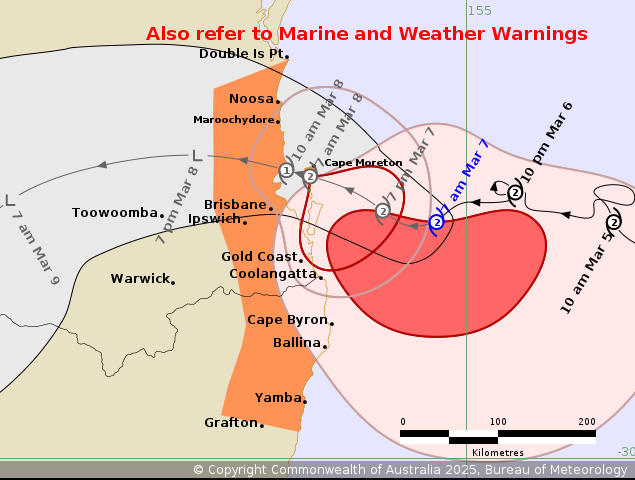
Warning Zone
Double Island Point in Queensland to Grafton in New South Wales,
including Brisbane, Gold Coast, Sunshine Coast, Byron Bay and
Ballina but not including Grafton.
Watch Zone
None.
Cancelled Zone
None.
Details of Tropical Cyclone Alfred 22U at 7:00 am AEST [8:00 am
AEDT]:
Intensity: Category 2, sustained winds near the centre of 100
kilometres per hour with wind gusts to 140 kilometres per
hour.
Location: within 20 kilometres of 27.6 degrees South 154.7 degrees
East, estimated to be 165 kilometres east of Brisbane and 140
kilometres east northeast of Gold Coast.
Movement: southwest at 6 kilometres per hour.
Tropical Cyclone Alfred will continue to move slowly towards the
southeast Queensland coast.
Alfred, a category 2 tropical cyclone is now expected to cross the
coast early Saturday morning, most likely close to Moreton Bay
between Noosa and Coolangatta.
Hazards:
HEAVY RAINFALL bands are continuing to extend over southeast
Queensland and northeast New South Wales coastal areas. HEAVY to
locally INTENSE RAINFALL which may lead to DANGEROUS AND
LIFE-THREATENING FLASH FLOODING is expected as Alfred crosses the
coast early Saturday morning. Once Alfred crosses the coast, it is
likely to weaken below tropical cyclone strength during Saturday.
Despite the weakening, the risk of significant impacts due to
widespread heavy rainfall is expected to continue near the coast
and extend over adjacent inland areas during the weekend. Refer to
separate Severe Weather Warning and Flood Watch current for
southeast Queensland and northeast New South Wales for
details.
ABNORMALLY HIGH TIDES are likely to continue causing MINOR
FLOODING of coastal low lying areas between Double Island Point and
Grafton, particularly during tonight's (early Saturday) high tide.
DAMAGING SURF leading to significant beach erosion remains likely
for the open beaches between Double Island Point and Grafton, and
further south over the New South Wales coast. Separate Coastal
Hazard and Hazardous Surf warnings are current for southeast
Queensland and New South Wales coasts.
Gales with DAMAGING WIND GUSTS to 120 kilometres per hour are
occurring near the coast between Cape Moreton and Cape Byron. Gales
with DAMAGING WIND GUSTS to 120 kilometres per hour are expected to
extend along the remaining southeast Queensland and northeastern
New South Wales coastal and island communities between Noosa and
Ballina later today as Alfred approaches the coast. These winds may
extend as far south as Grafton and northwards to Double Island
Point in the evening or Saturday morning.
DESTRUCTIVE WIND GUSTS of up to 155 kilometres per hour are likely
to develop about coastal and island locations near, and to the
south of, the cyclone centre, as Alfred's destructive core
approaches the coast later today. The destructive winds may persist
until Alfred crosses the coast early Saturday morning.
Although Alfred is expected to weaken and move inland during
Saturday, DAMAGING WIND GUSTS may continue, particularly over
elevated terrain during Saturday, before easing throughout during
Sunday.
Refer to associated warnings for Queensland and New South Wales at
http://www.bom.gov.au/australia/warnings.
Recommended Action:
People between Cape Moreton and Cape Byron, including the Morton
Bay Islands should immediately commence or continue preparations,
especially securing boats and property.
People between Cape Byron and Grafton in New South Wales, as well
as Brisbane and Double Island Point in Queensland should take
precautions and listen to the next advice.
- For cyclone preparedness and safety advice, visit the Get Ready
Queensland website (www.getready.qld.gov.au)
- If you choose to take shelter away from your home, stay COVID-19
safe and pack a mask and hand sanitiser (if you have them).
- For emergency assistance call the Queensland State Emergency
Service or New South Wales State Emergency Service (SES) on 132 500
(for assistance with storm damage, rising flood water, fallen trees
on buildings or roof damage).
Current
Tropical Cyclones
06/Mar/2025 10:06 PM


