
Source: Bureau of Meteorology
Issued at 2:55 pm WST on Friday 6 February 2026
Headline:
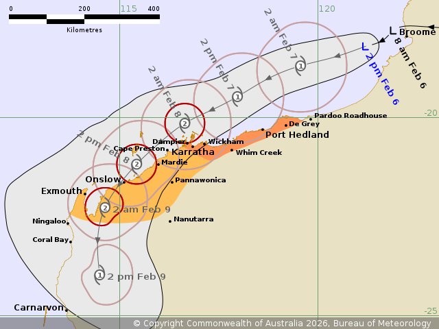
Tropical Low 21U is expected to develop into a tropical cyclone
early Saturday morning, to the north of the Pilbara coast.
Areas Affected:
Warning zone: De Grey to Dampier, including Port Hedland, Dampier
and Karratha
Watch zone: Cape Preston to Exmouth, including Onslow, and
extending inland through the western Pilbara to include
Pannawonica.
Cancelled zone: None.
Details of Tropical Low 21U at 2:00 pm AWST:
Intensity: Tropical Low, sustained winds near the centre of 55
kilometres per hour with wind gusts to 85 kilometres per
hour.
Location: within 35 kilometres of 18.2 degrees South 121.2 degrees
East, estimated to be 115 kilometres west southwest of Broome and
360 kilometres northeast of Port Hedland.
Movement: west southwest at 14 kilometres per hour.
Tropical Low 21U is located over water to the west of Broome. It
is forecast to develop into a tropical cyclone early Saturday
morning.
Over the weekend, 21U will continue to move in a general west
southwest direction, remaining offshore initially but moving closer
towards the Pilbara Coast. It should continue to develop and is
likely to reach category 2 intensity by Saturday evening.
It may turn in a more south-westerly direction on Sunday and
impact the western Pilbara.
Hazards:
DESTRUCTIVE WIND GUSTS to 150 km/h are possible for coastal parts
of the Pilbara around Karatha, Dampier and Wickham from Saturday
afternoon if the centre of 21U approaches the coast. Destructive
winds may extend further west along the coast towards Onslow and
Exmouth during Sunday.
GALES with DAMAGING WIND GUSTS to 120 km/h are possible for
coastal parts between De Grey and Mardie during Saturday, extending
west to Onslow and Exmouth and through inland parts of the western
Pilbara including Pannawonica on Sunday.
Widespread moderate to locally HEAVY RAINFALL which may lead to
FLASH FLOODING is possible from later tonight with this risk
persisting through the weekend for the Pilbara coast.
Tides between Wickham and Exmouth are likely to rise above the
normal high tide mark on Saturday and Sunday and LARGE WAVES may
produce FLOODING of low-lying coastal areas.
Recommended Action:
Ensure you know what to do in a cyclone. For the latest DFES
community alerts and warnings visit www.emergency.wa.gov.au or
download the Emergency WA app.
Current
Tropical Cyclones
06/Feb/2026 07:11 AM


